Still at Cuverville Island, the local gentoo penguin colonies were an attraction, as well as the resident blue-eyed shags. After Cuverville we intended to embark on a series of visits to a few Antarctic bases. At Water Boat Point, on a tiny island immediately adjacent the mainland, the Chileans have a small installation, while a distance offshore, a UK charity looks after an even smaller British base set-up during the war.
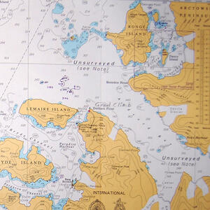
Despite this human presence, the “unsurveyed” notes on the chart are typical.
Cuverville Island, Water Boat Point, and Neumayer Channel
There was more evidence of the whaling past. This chain and cable was wrapped around the rocky outcrop of a small islet in the middle of the bay at Cuverville Island. Whalers probably used it to tie to in the old days.

On the island hillsides, a large gentoo penguin colony is established. Parents stand guard over chicks.

The chicks here were younger than they were farther north. This is because the whole breeding cycle gets started later in the colder environment.

A better model for a child’s soft toy could not be found.

The penguins have a good view of the bay.

Moving on, we came to the first of a few bases we intended to visit. This is Water Boat Point, where the Chileans have an answer to the Argentines.

We were moored directly between the base, which is built on a small isle, and the continent coast. Glaciers and mountain ranges climbed away behind us.

In front of us was the largest iceberg we see on this trip – so large it took us a while to realize that it was not in fact part of the land.

The Chilean Armada boys have a good view from their observation tower. The pink in the snow is not reflected sunlight nor penguin guano; it is pink algae which lives in the top layer of snow.

The color here is all sunlight though.

Leaving the continent behind, we headed out to a group of large islands off the coast. Below, the flat plateau that the ice-cap provides to the entire Peninsula is apparent from distance.

This is the Neumayer Channel, a famous passage between dramatic walls of mountain ranges which rise steeply out of sea.

This colorless landscape is reminescent of something from Tolkien. Mountain peaks march into the distance.

We were on our way to Port Lockroy, a British base dating from the war. Its presence is marked by some small black huts and radio antennae.

“Base A” Port Lockroy was established by the British in 1944 as part of “Operation Taberin”, intended to both report on German activities in the region and provide weather reports. The base is now abandoned by the British Antarctic Survey, which has consolidated its investments into the larger British bases farther south. Lockroy however is maintained and run as a museum by a British charity organization. They send a small team down every summer to do maintenance work and run the museum shop which mostly funds their efforts. Here, Rick and Nicky are working on cement steps to assist visitors from cruise ships.

The penguins have no interest in such dull activities, and continue to colonize the island as they always have.

On the other side of the bay, the local penguins have another intrusion into their landscape to contend with. These right whale bones are another leftover from whaling days.

Port Lockroy is dominated by the terrain that surrounds it. The little huts have so far managed to brave the odds, and the flag seems a symbol of man’s endurance in the face of the natural world.

